


Taklamakan - Taklimakan Desert
As the largest desert in China, the Taklimakan desert accounts for about 20% of the total area of Xinjiang, about the same size of 50 Shanghai. The whole desert is 1000 kilometers long from east to west and 400 kilometers wide from north to south, covering an area of about 330,000 square kilometers. The average annual precipitation is no more than 100 mm, and only 45 mm when it is low; The average evaporation is as high as 2500 ~ 3400 mm. Here, pyramid-shaped sand dunes stand 300 meters high. The strong wind can blow the sand wall up to three times its height. The sand dunes in the desert are continuous. Affected by the wind, the sand dunes often move. It is not only the largest desert in China, but also the tenth-largest desert in the world, and the second-largest shifting desert in the world, second only to the Rubkhari desert of the Arabian Peninsula (650,000 square kilometers).
Where Is Taklamakan Desert
Taklamakan desert is situated in the center of Tarim Basin in southwest Xinjiang in Northwest China, starting from Korla in the East, Kashgar in the west, Hotan in the South, and Aksu in the north. It is bounded by the Kunlun Mountains to the south, the Pamir Mountains to the west, the Tianshan range to the north, and the Gobi Desert to the east.
How Was the Taklamakan Named
There have been different views on the name of this vast desert in history. It was not until modern times that the local Uighurs officially gave this desert a vivid name. “Takla" comes from a Uighur noun, which means "below" or "of origin and ancestry ". “Makan" means "place and residence " in the modern Uyghur language. Therefore, "Takla" and "Makan" together, in Uighur means "residence under the desert" or “place of origin". The name in Uighur accurately and faithfully reflects the historical facts of this largest desert in China.
How Was Taklamakan Desert Formed
The formation of the Taklimakan desert is related to the internal force of the earth's crust. The Taklimakan mountains were formed in the Tarim Basin, which is a huge closed Intermountain basin surrounded by Tianshan Mountains, Kunlun Mountains, and Altun Mountains. Due to the strong collision and compression between the South Asian subcontinent and the Eurasian Plate, the Himalayas and the Qinghai Tibet Plateau uplifted, and the strong orogeny also formed huge folded mountains such as the Kunlun Mountains and the Tianshan Mountains, and Tarim Basin is located deep in the Eurasian continent and very far away from the ocean. In addition, it is difficult for water vapor to enter due to the obstruction of the surrounding tall mountains. The climate type belongs to the temperate continental climate with drought and little rain. The annual precipitation of Tarim Basin is less than 100 mm, but the annual theoretical evaporation is more than 2500 mm. The basin is covered with thick continental sediments with a maximum thickness of more than 10000 meters. These sediments are the material source of the Taklimakan Desert. Under the continuous erosion of wind force, A large number of sand grains accumulated, transported, and moved, forming countless mobile sand dunes, and finally forming the Taklimakan Desert.
★ Recommended Taklamakan Desert Tour: 13 Days Xinjiang Silk Road Adventure Tour
 Taklamakan Desert Location Map (Click to Enlarge)
Taklamakan Desert and Silk Road
The world-famous silk road connects Central Asia and Europe all the way west along the northern edge of the Taklimakan Desert, promoting cultural exchanges between the East and the West. Around the northern border of Taklimakan desert and even in the hinterland of the desert, many cultural relics of the Han and Tang Dynasties and many large-scale ancient city sites have been found. Down to the Niya River Valley which is more than 100 kilometers into the Taklimakan Desert, people found that the beams and columns of many houses were buried in the sand. The most famous site is the Niya ruins. Although the site has gone damaged, some buildings can still be recognized, as the traditional large living room in Turkistan, and some buildings are the same as those in central China, with beautiful cornices, arches, and carvings on beams and columns. Among these ruins, there are many ancient relics, including bows, arrows, shields, spears, etc; From the perspective of utensils, there are ancient Greek patterns and Chinese carving. Relics from different countries were brought here through the silk road, and in ancient times the means of transportation they could rely on could only be camels. How could the ancient people leave so many treasures in the desert? Why did these ancient countries perish? The Taklamakan remains mysterious with lingering countless questions till today.
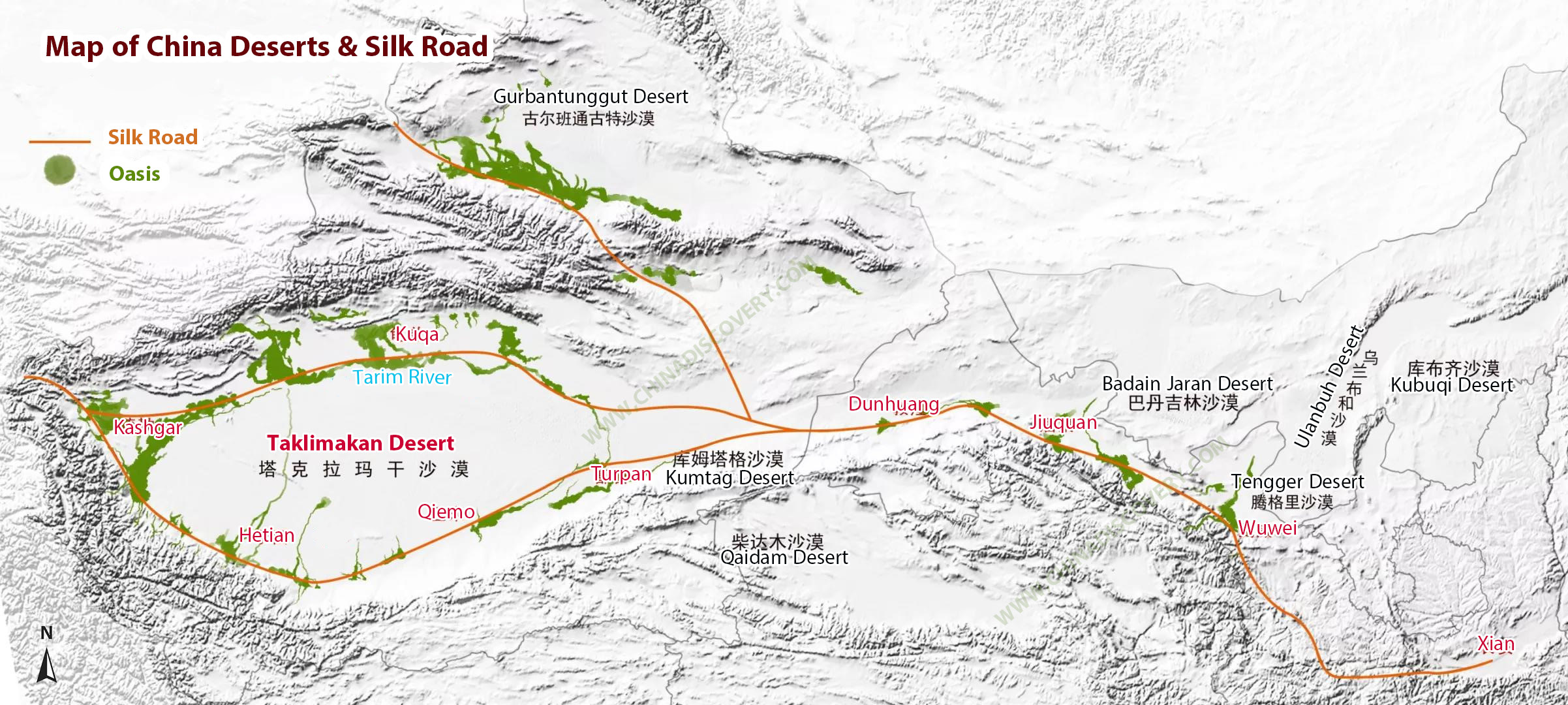
Map of China Deserts and Silk Road (Click to Enlarge)
Taklamakan Desert Climate
The climate of the Taklimakan desert is continental, and the annual maximum temperature is 39 ℃. The annual precipitation is very low, ranging from 38 mm in the west to 10 mm in the East. The temperature is high in summer, up to 38 ℃ in the eastern edge of the desert.
Taklimakan desert is hot and arid, with the maximum temperature of 67.2 ℃ in hot summer and the temperature difference between day and night is more than 40 ℃; The average annual precipitation does not exceed 100 mm, and the lowest is only 4 to 5 mm, while the average evaporation is as high as 2500 ~ 3400 mm.
The average temperature in January is - 9 ~ - 10 ℃, and the minimum temperature in winter is generally below - 20 ℃. One-third of the year is a sandstorm day. As the whole desert is affected by the intersection of the two prevailing wind directions of northwest and north-south, the wind sand activities are very frequent and intense, and the shifting sand dunes account for more than 80%.
In spring, the northeast wind is particularly strong. During this period, strong hurricane dust storms often occur, filling the atmosphere with sand and dust, up to 3962 meters above sea level. During the day, Taklimakan is scorching. The sand surface temperature is sometimes as high as 70 ~ 80 ℃. Vigorous evaporation makes desert travelers often see a hazy "mirage" in the distance.
Best Time to Visit Taklamakan Desert
The best time to visit the Taklamakan desert is from late October to mid-November every year, especially for crossing the Taklimakan Desert. This is the dry season with fewer dust storms in Taklimakan, and there are fewer mosquitoes. At the same time, the leaves of Populus euphratica in Tarim Basin turn golden, and the scenery is very charming.
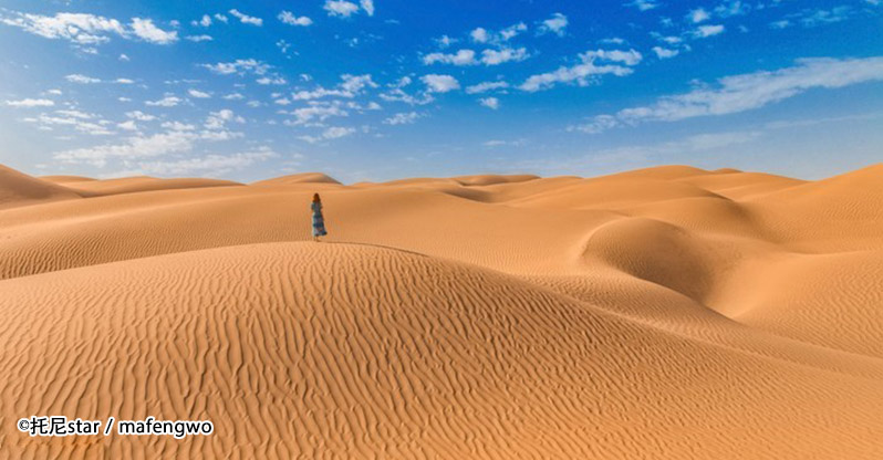
Taklamakan Desert Scenery ©托尼star / mafengwo
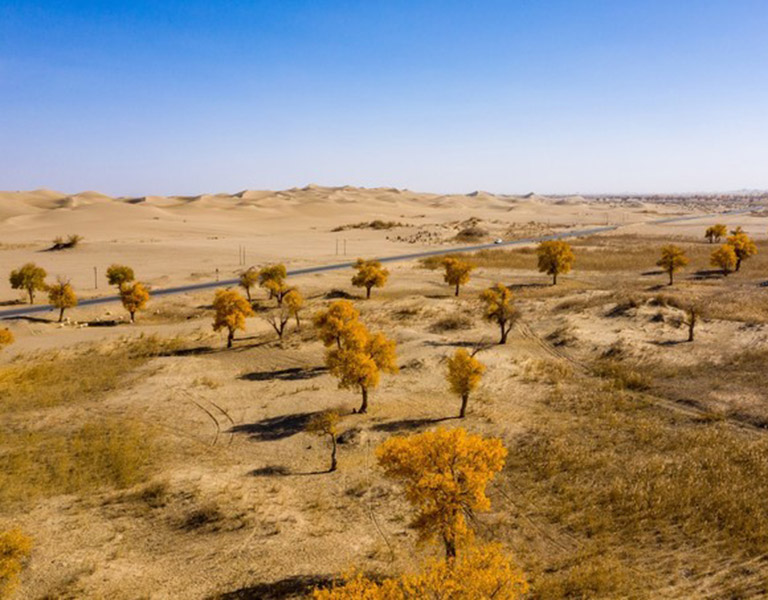
Populus Euphratica Trees in the Desert ©CrazyWolfkin / mafengwo
Wearing & Packing Tips
- Clothing: Bring outdoor windproof, sandproof, and quick-drying clothes; bring sunblock items like sunglasses (goggles), sunhat, sunscreen, headscarves, masks, to reduce skin exposure, and remember to cover your neck. In the morning and evening, wear a light warm coat, or down jacket and take off at noon.
- Shoes: Wear high-top climbing shoes or desert boots when crossing the desert on foot and bring a sandproof shoe cover.
- Water: You can carry as much water as you can, and you can take two water bottles to fill them with water.
- Supplement: Electrolyte tablets, energy drinks, energy bars, raisins, snacks.
- Other Items: Walking stick, sleeping bags; medicine, toiletries, mosquito repellents, mobile power, camera, and sandproof covers, etc. Learn more about China Desert Tips
How to Travel Taklamakan Desert
Taklimakan desert is known as the "desert of death". Among the major deserts in the world, the Taklimakan desert is very mysterious and attractive. However, in this awesome but dangerous desert, there are two very unique roads G216 and G217 running through it. The two roads are grand projects to conquer the "desert of death". They are usually the ways for tourists and explorers to cross the Taklimakan Desert.
★ Recommended Taklamakan Desert Tour: 9 Days Taklamakan Desert Ancient Silk Road Tour
The First Desert Highway, Luntai - Minfeng desert highway, is about 580km and takes about 9 hours by car. There is basically no accommodation on the way, so the itinerary should be arranged in one day as far as possible.
What to See: Minfeng County is becoming more and more famous due to the relics of Jingjue's ancient city. You can go to the local museum to see the exhibits from the famous Niya ruins. Out of Minfeng County, you can drive northward along the Niya river. On the roadside and the edge of Taklimakan Desert are quiet lakes, grassland, and the endless Taklimakan Desert, forming a vast and magnificent picture of nature. Cattle and sheep enjoy the gifts of nature leisurely on the grassland. After driving from Minfeng County along with G315 to the desert highway, both sides of the highway began to become desolate. Only Populus euphratica forest still survives in such a harsh environment.
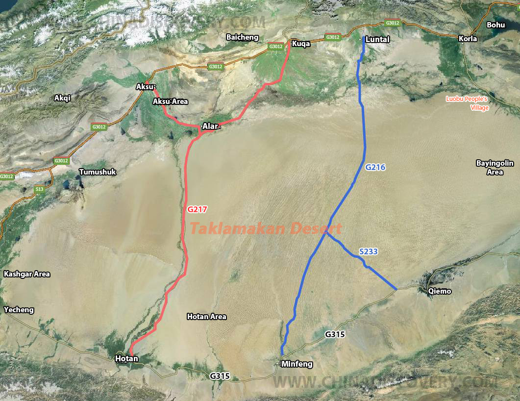
Taklamakan Desert Highway Map
The Second Desert Highway, the Alar Hotan desert highway, is 440km long. It takes about 6 hours by car. There is still no accommodation along the road, but fortunately, the distance is short enough to arrive in one day.
What to See: About two hours' drive from Luntai, the car begins to drive into the desert, Alar desert highway. There are no villages, pedestrians, cattle, and sheep on both sides of the road, leaving only the endless desert. March and April in the Taklimakan desert is the season of the high incidence of dust storms here. The strong wind rolls up the dust like a tall sand wall. When the sandstorm occurs, the dense sand covers the sky and blocks the sun, and the visibility decreases when driving. Walking on the desert highway can be spectacular, but dangerous without a guide. There are often some ruins on both sides of the highway.
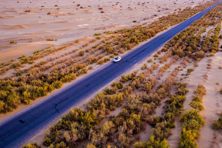
Taklamakan Desert Highway ©CrazyWolfkin / mafengwo
Tips on Driving Cross Taklimakan Desert
1. The overall road conditions of the two desert highways are good, basically asphalt pavement, and occasionally there are small pits. As long as you drive carefully, all kinds of vehicles can pass through.
2. There is not any gas station on the desert highway. When crossing the desert highway, pay attention to the oil volume.
3. If you want to experience desert camping, you must pay attention to the weather conditions. April is the high incidence period of dust storms. Avoid outdoor camping during dust storms.
4. To experience desert hiking, you need to have a good physical condition and rich outdoor experience or follow an experienced guide and pay attention to weather changes.
5. There are basically no accommodation places on the two desert roads. When arranging the trip, the desert crossing needs to be completed in one day.
If you don't have time to drive cross the Taklimakan Desert, it is recommended to go to Luobu People’s village to experience the desert and Luobu People’s culture.
Luobu people's village is located in southwest of Yuli County (尉犁县), about 35 kilometers away from the county center. Here you can visit many buildings such as houses and sacrificial platforms of Luobu people, as well as the scenery of desert, Tarim River, and Populus euphratica forest. Luobu people is one of the ancient nationalities in Xinjiang. This nation has been isolated and stay mysterious from other nations for thousands of years. It has a unique culture and folk customs. As soon as you enter the scenic area, you can see the surrounding sand dunes and Gobi scenery. Tourists need to take a shuttle bus here to enter the village. You can see many tall Populus euphratica trees along the way, with desolate and magnificent scenery. After entering the village, you can see their houses, altar, and other unique buildings of the Luobu people, as well as the local song and dance performances. Tourists can also experience camel riding. Boating in the desert lake is also very interesting.
How to Get to & Around Taklimakan Desert
Taklamakan covers a large area with many cities lining around it such as Korla, Kuqa, Alar, Asku, Luntai, Yecheng, Hotan, Minfeng, Qiemo, etc. You can get to Taklamakan Desert and enjoy the desert scenery with multiple options on arrival.
For visitors who would like to visit the Luobu People's village, they can take a flight (1h) / train (4-5.5h) from Urumqi to Korla and charter a private car from Korla downtown to Luobu people's village (about 80km, 2h by car) in Yuli county.
If you would like to experience the desert highways, you are recommended to get from Asku, Kuqa, or Luntai which are important outpost cities along the ancient silk road and near or on the G3012 highway (Turpan - Hotan Highway). You can easily take a flight to Kuqa (1h) or Asku (1.5h) from Urumqi. Trains are also available to Asku (9.5-11.5h) and Kuqa (7.5-9.5h). You can have a driver take you to Alar on your first day and stay at Alar. On the next day, you can travel through the desert along highway G217 to Hotan. Also, if you would like to travel backward, you can arrive at Hotan from Urumqi (2h by flight) first and drive back to Alar.
As for the second desert highway - G216, you can start your trip from Luntai or Mingfeng. There is no direct flight to the two counties. Travelers can take a train from Urumqi to Luntai (7.5-8h), besides you can drive along G3012 to Luntai passing Turpan and Korla. Or, you can drive along G315 from Hotan to Mingfeng (about 290km, 5.5h by car) and even to Qiemo. The scenery along G315 is stunning with vast desert and snow peaks afar as the backdrop.
China Discovery’s Private Transfer is Top Recommended
As attractions are scattered in different directions and the desert traveling can be dangerous sometimes, traveling with a private vehicle and a professional local guide is quite necessary and helpful. To better acclimatize yourself to the local environment and get a better travel experience, it’s highly advised to get around Taklimakan by private car. Please feel free to contact us for transportation help.
Keep Reading
- Xinjiang Tours
- Urumqi Tours
- Kashgar Tours
- Turpan Tours
- Kanas Tours
- Tashkurgan Tours
- How to Plan Xinjiang Trip
- Xinjiang Destinations
- Xinjiang Attractions & Things to Do
- Xinjiang Weather & Seasons
- Xinjiang Transportation
- Xinjiang Maps
- Xinjiang Tips
- Urumqi Travel Guide
- Turpan Travel Guide
- Kashgar Travel Guide
- Shache Travel Guide
- Altay Travel Guide
- Hotan Travel Guide
- Kucha Travel Guide
- Ili Travel Guide
- Taklamakan Desert
- China Desert Maps
- China Desert Tips
Recommended Taklamakan Desert Tours
Top 3 Taklamakan Desert tours chosen by most customers to explore Taklamakan Desert in the best way. Check the detailed itinerary, or tailor your own trip now with us.

13 Days In-depth Xinjiang Silk Road Adventure Tour
Urumqi / Turpan / Korla / Kuqa / Taklimakan Desert / Minfeng / Hongtan / Kashgar / Tashkurgan

8 Days Classic Xinjiang Tour including Urumqi Turpan Kashgar Tashkurgan
Urumqi - Turpan - Kashgar - Tashkurgan
 in the morning of September")
9 Days Taklamakan Desert Ancient Silk Road Tour
Kashgar / Karakul Lake / Hotan / Ala'er / Kucha / Urumqi

Start planning your tailor-made holiday to China by contacting one of our specialists. Once inquired, you’ll get a response within 0.5~23.5 hours.
Customize a Trip


Have a question? Get answers from our travel experts or guests
- Your Question:
- Your Name:
- Your Email:
- Submit

